
- E N D E
 Ende
was the site of a kingdom
that existed around the end of the 1 8th century. The name today
refers to the capital of the Ende regency, which includes the
two autonomous territories of Lio and Ende. The people of the
area therefore known as Lio Ende people. This town has
for many decades been a center of government trade, education
and political activity. Rebellion against the Dutch, led by a
certain Nipa Do - known as the Wars of Watu Api and
Mari Longa - decurred here in 1916 - 1917. And in 1934,
the traditionalist leader Soekarno, who was later to become
Indonesia's first president, was exiled to Ende by the
Dutch colonial government.
Ende
was the site of a kingdom
that existed around the end of the 1 8th century. The name today
refers to the capital of the Ende regency, which includes the
two autonomous territories of Lio and Ende. The people of the
area therefore known as Lio Ende people. This town has
for many decades been a center of government trade, education
and political activity. Rebellion against the Dutch, led by a
certain Nipa Do - known as the Wars of Watu Api and
Mari Longa - decurred here in 1916 - 1917. And in 1934,
the traditionalist leader Soekarno, who was later to become
Indonesia's first president, was exiled to Ende by the
Dutch colonial government.
- The town Ende lies at the foot of mountains lye, lpi, Meja and Wongge. The beautiful bays of Ende, lpi, and Mbuu are favorite sites for beach-site recreation. Ende can be reached by aircraft from Kupang. And also from Denpasar via Bima, or by from Surabaya or Kupang.
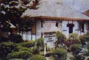
- The Bung Karno Museum is the old house occupied by Soekarno during his years of exile in Ende. Most of for the old furnishings are still there.
- While in exile in Ende, Soekarno wrote and staged few plays, together with the Tonel Kelimutu theatre troupe. Among those plays were Rendorua Ola Nggera Nusa (Rendo That Stirred the Archipelago) and Doctor Satan, a revision on the story of Dr. Frankenstein.
- Near the football field in Ende stands an old, big breadfruit tree. Under it, Soekarno often sat, working on political ideas to lead Indonesia towards independence. Those reflections presumably contributed to the opening of the Pancasila concept, which is now the state philosophy of the Indonesian Republic. Just from here was the Pancasila idea born. Today, the Pancasila Birth Monument stand on this precise spot.
- The town Ende lies at the foot of mountains lye, lpi, Meja and Wongge. The beautiful bays of Ende, lpi, and Mbuu are favorite sites for beach-site recreation. Ende can be reached by aircraft from Kupang. And also from Denpasar via Bima, or by from Surabaya or Kupang.
-
- KELIMUTU
 East
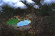
Nusa Tenggara's natural wonder and one of Indonesia's most mysterious
and dramatic sights that can be found on top this mountain, some
66 kilometers from Ende, or 83 kilometers from Maumere. It has
a unique and spectacular view on its three crater lakes with
their respective colors. The colors, however, have changed continually
since the eruption of Mount /ye in Ende in 1969.
East
Nusa Tenggara's natural wonder and one of Indonesia's most mysterious
and dramatic sights that can be found on top this mountain, some
66 kilometers from Ende, or 83 kilometers from Maumere. It has
a unique and spectacular view on its three crater lakes with
their respective colors. The colors, however, have changed continually
since the eruption of Mount /ye in Ende in 1969.
- The mountain is located at the back of Mount Kelibara, in the Wolowaru District in the Ende, Regency of Central Flores. Keli means mountain and Mutu means boiling. In short, it means volcano. To the local people, this mountain is holy, and a token of God's blessings. It provides fertility to the surrounding lands. It is both heaven and the hell to the people of Lio Ende.
- Many travelers and scientists, have written about Kelimutu since it was discovered by Van Suchtelen, a Ducth government officer,
in 1915.- Father Bouman published an article in 1929, which made the name Kelimutu known all over the world. Since then, many researchers and tourits have come, as well as the Governor General of Batavia (Jakarta). To get to the lakes, one follows the road, from Moni, then proceed to the crater's top. Near the crater rim was a bungalow, which has now been dismantled.
- The presence of the white men, or Ata Bara, was regarded disturbing to the peace of the ancestral spirits. As a result the spirits of Kelimutu disappeared. Earth quakes began rocking the land. Smoke is often released from the crater.
- The eruption of 1928 caused many victims and much damage. In 1938 there was another eruption, coming from Tiwu Ata Koo Fai Noo, Ata Nuwa Muri (the Lake of Youth). The biggest took place in 1968, in which the water in the lakes was shot 10 kilometers high into the sky. The peak of Kelimutu itself is 1,690 meters high, and its lake crater I ,410. Other geological data are as follows: Tiwu Ata Polo (the Lake of Evil) has a slopping wall, 150 meters high. The lake is 380 by 280 meters large and 64 meters deep. The volume of the water is about 446,000 cubic meters.
- Tiwu Ata Koo Fai Noo and Ata Nawa Muri (the Lake of Youth) has walls 128 meters high. The lake is 430 by 300 square large and 127 meters deep with a water content of about 500.000 cubic meters.
- Timu Ata Bupo (the Lake of the old) has twi layers of walls, 240 meters high. The lake covers a surface of 300 by 280 meters high. The water is 67 meters deep and 345,000 cubic meters in volume. The total water content of the three lakes amounts to 1,3 million cubic meters.
- In the last three ti five years, the lakes of Kelimutu have changed in color, a phenomenon caused by the geological and chemical processes in the bottom and walls of take lakes. It could also have resulted from changes in the bacteria and micro organism populations due to changes in temperature.
- Another theory proposed by village elders, is that there has actually been no change at all, but that the effect is due to optical illusions. To reach Kelimutu can be done by flying to Ende or Maumere, then going by car to Kelimutu.
- The surrounding villages are good places serving as bases for visits to Kelimutu, particularly those who wish to have a more leisurely pace and enjoy the views along the road between Ende and maumere, or spend more time in Kelimutu. Those title villages are also known for their excellent weaving all hand made, still use natural dyes.
- The mountain is located at the back of Mount Kelibara, in the Wolowaru District in the Ende, Regency of Central Flores. Keli means mountain and Mutu means boiling. In short, it means volcano. To the local people, this mountain is holy, and a token of God's blessings. It provides fertility to the surrounding lands. It is both heaven and the hell to the people of Lio Ende.
|
|
|
Click here to see :
West Nusa Tenggara Map
East Nusa Tenggara Map
Indonesia Maps
(There are 33 High Resolution Maps on here)
West Nusa Tenggara Tourism
East Nusa Tenggara Tourism
Indonesia Tourism
(There are complete info about 33 provincies : Object Tourisms, Hotels, Travel agents, etc)
www.nusa-tenggara.com