|

- R U T E NG
- Ruteng is the capital of Manggarai Regency that
was once ruled by the kings of Bima. The influences of Bima.
The influences of Bima and Goa are evident in prevailing titles,
such as Karaeng, and in the manner of dress. The shape
of the roofs with the buffalo horn symbol, may be an element
inherited from the Minangkabau. The cool town of Ruteng lies
at the foot of a mountain. It can be reached by air from Kupang
or Denpasar via Bima, or by ferry from Bima via Labuanbajo, or
from eastern part via Ende and Bajawa.
- Beside the fame Komodo lizards,
the area has many attractions to offer the tourists, such as
the caci dance, a wildlife reserve, and archeological caves.
-
- R E O
- In previous centuries, Reo
was the part of considerable trading potentials.
- Liang Bua is a cave 13 kilometers from Ruteng, which
not so long ago caused minor sensation due the finding of rare
prehistoric fossils.
- Ulumbu, Lying far behind the mountains and
near the southern coast, has a geyser, spurting water 15 meters
high into the sky. The place, however, is not easy to reach.
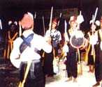
- Caci is an interesting dance. Two warriors
wearing traditional clothes face each other, each holding a shield
in the left hand and a lash whose tip is covered with dried buffalo
skin, in the right. This dance is accompanied by gong beats,
and preceded by chants, sung by males.
- Horse Races can be seen in
Karo Village. south of Ruteng. In former times, such races
drew participation from as far as Bajawa, Boawae, and even Ende.
- Magic is said to be often
involved and usually held during holidays.
- Mount Pocoranaka is the highest mountain on Flores Island,
and practically unexplored.
- Ranamese is a big lake in the mountains. The air
is cool and sometimes misty, good for relaxing, water
sport and fishing.
-
- LABUANBAJO
- A little town inhabited by
fishermen, lies at the extreme western part of Flores Island.
The town serves as a jumping off point for the trip to Komodo
Island. It is a beautiful area for water skiing, wind surfing,
fishing and many other marine activities.
- Pade Beach is an ideal place to do all this and from
here sunsets are beautifully visible.
- In south of Labuanbajo there
is a large and wellknown hunting park called Waewuul.
- The surrounding of Rinca Island
and the Rinca Island Marine Park are still unspoilt and not much
visited.
- There is the old Padar,
or Ninunakeng Marine Park. Boastmen in Labuanbajo
always take visitor there.
- On the way back, visit the
Mutiara - pearl breeding farm in Laboanbajo. New Labuanbajo Bay
are dozens of islands and coral rocks set in a calm, blue water.
- Batu Cermin Cave is five kilometers from the town of Labuanbajo.
It can be reached partly by car, and partly on foot. The grotto
is 75 by 75 meters large, and contains stalactites and stalagmites.
Some tunnels are narrow and dark but in others sunlight falls.
- The cave of Batu Susun is
located near Batu Cermin. It is 5,000 square kilometers large.
Thorny bushes block the cave's entrance, but for those
who are willing to brave them there was ample reward inside.
- Another challenging site near
Labuanbajo is Waraloka Cave. Antique ceramics have been found
here.
-
- BIDADARI ISLAND AND SURROUNDING
 This
small island is only 14 or 15 hectares large and is located in
Labuanbajo Bay can be reached by motorboat. The island is covered
with many hills, grow with trees and surrounded by fine white
sand. Fishes swim in the water, which is calm and transparent. This
small island is only 14 or 15 hectares large and is located in
Labuanbajo Bay can be reached by motorboat. The island is covered
with many hills, grow with trees and surrounded by fine white
sand. Fishes swim in the water, which is calm and transparent.
- Kalong Island is 10 miles from Labuanbajo. The island
derives its name from the thousands of bats which line trees.
- Pulau Monyet. or Monkey Island, is only about
half a mile away from Labuanbajo. Plenty of smart monkeys live
on this island.
- At Liang Dara an ancient
civilization once existed. The site is reminiscent of Liang Bua,
where fossils were found.
-
- KOMODO ISLAND
 A
small island of 280 square kilometers, Komodo is located between
the island of Sumbawa and Flores. The island is almost all hill
and barren except for palm trees and some wood but it is famous
for its giant lizards which are considered the last of their
kind remaining in the world today. To many modern naturalists,
East Nusa Tenggara is so particularly interesting, because of
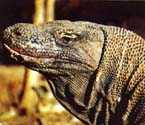
this unique species, called the Komodo Dragon. Called
"ora" by the local people, Komodo "dragon"
(Varanus Komodoensis) is actually a giant monitor lizard. Growing
up 3 to 4 meters in length, its ancestors roamed the earth up
to about half a million years ago. A
small island of 280 square kilometers, Komodo is located between
the island of Sumbawa and Flores. The island is almost all hill
and barren except for palm trees and some wood but it is famous
for its giant lizards which are considered the last of their
kind remaining in the world today. To many modern naturalists,
East Nusa Tenggara is so particularly interesting, because of
this unique species, called the Komodo Dragon. Called
"ora" by the local people, Komodo "dragon"
(Varanus Komodoensis) is actually a giant monitor lizard. Growing
up 3 to 4 meters in length, its ancestors roamed the earth up
to about half a million years ago.
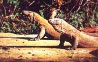
- Komodo live on carrion of
goats, deers, and even the carcasses of their own kind. They
are wild and move with their bodies raised on their four legs.
At two fixed locations, visitors can watch their behaviors. The
Komodo National Park includes the water around Komodo Island,
Rinca and some other tiny island in the group. The park is 59,000
hectares large.
- Such giant lizards have also
been found around Manggarai, Riung, Ngada, and even in the northern
areas in the Ende Regency.
- Komodo is now a nature reserve
being part of a national park. It is home to a number of race
bird species, deer, and wild pigs, which are prey to the lizards
as well. The only human population on the island is at the fishing
village called Komodo who supplement their income breeding goats
which are used to feed the lizards.
 The
Komodo is protected by law and though they are considered harmless,
it is advisable to keep them at a distance. The
Komodo is protected by law and though they are considered harmless,
it is advisable to keep them at a distance.
- To see the lizards in the
day time; baits have to be set in the hinterland where local
guides are necessary. The sea surrounding the island offers vistas
of sea live, crystal clear water, and white sandy beaches The
only accommodation available is in simple guess houses in the
fishing village.
- It is advisable to carry food
supplies. The best time to visit the island is between March
and June, and between October and December. Komodo is accessible
from the sea only fly to labuanbajo, from where it is about 3
- 4 hours by boat to the island.
-
- NGADA
 From
Ruteng the road leads east toward the Regency of Ngada. Ngada
has plenty of ancient villages in which the people still practice
the old cult of ancestral worship. It is not surprising to find
in every village, a mezbah, dedicated to the spirits of the ancestors. From
Ruteng the road leads east toward the Regency of Ngada. Ngada
has plenty of ancient villages in which the people still practice
the old cult of ancestral worship. It is not surprising to find
in every village, a mezbah, dedicated to the spirits of the ancestors.
-
- BAJAWA
- The capital of Ngada is Bajawa,
which lies in the middle of the cool highlands. It is a pleasant
little town such as is seldom found elsewhere in Flores. About
135 kilometers from Ruteng all about 5 to 7 hour - driving distance
by car, Bajawa can also be reahed from Kupang by air-craft, and
from Ende by car.
- Abulobo and Inerie are between
mountains with sharp peaks known locally as the "sky pillars",
and popular among mountaineers. They are located near coast and
have wonderful scannery.
|